
The Whole Is Greater Than the Sum of Its Parts
What water does to the value of Arizona farm and ranch land
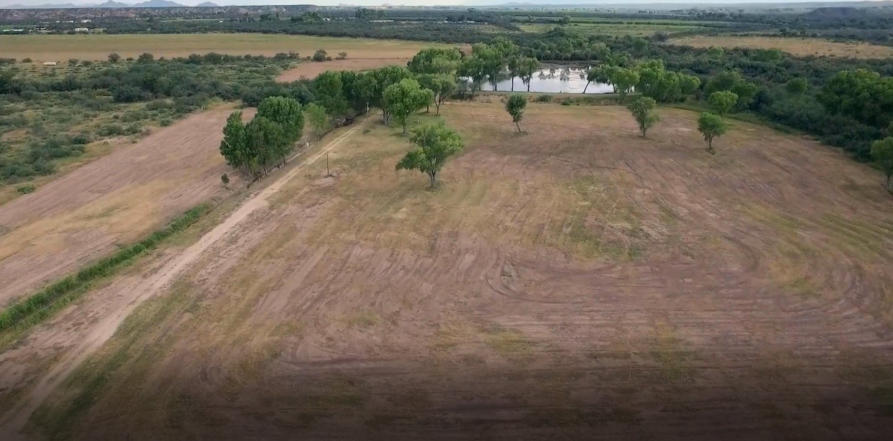
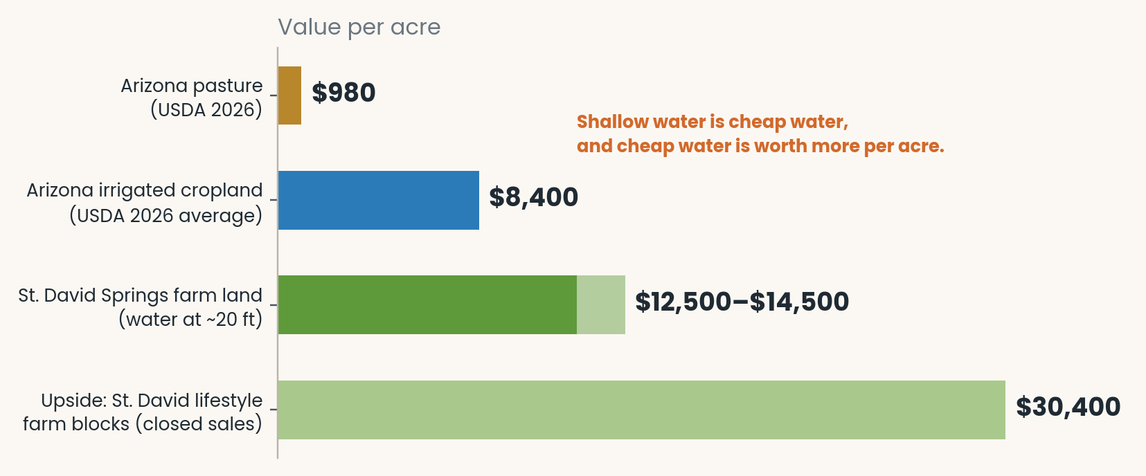
In southern Arizona, an acre of grazing land is worth about $980. An acre of irrigated cropland is worth about $8,400. That gap is the whole story of farm and ranch value in the desert.
Almost. The rest of the story is how deep the water sits. At St. David Springs, water stands about 20 feet below the surface and costs almost nothing to lift, and that makes the same irrigated acre worth more again: about $12,500 to $14,500 as a working farm.
Fertile soil with no water is pasture at best. A well with no good soil under it is an expensive hole. Put the two together, prepare the ground, and add a way to deliver the water, and you have something worth far more than its pieces. This post explains why, what each piece costs to build today, and how to judge a property that already has them.
Land and water are worth more together
USDA’s 2026 land value survey puts Arizona pasture at $980 per acre and irrigated cropland at $8,400 per acre. Same state, same survey, more than 8 times the value per acre.
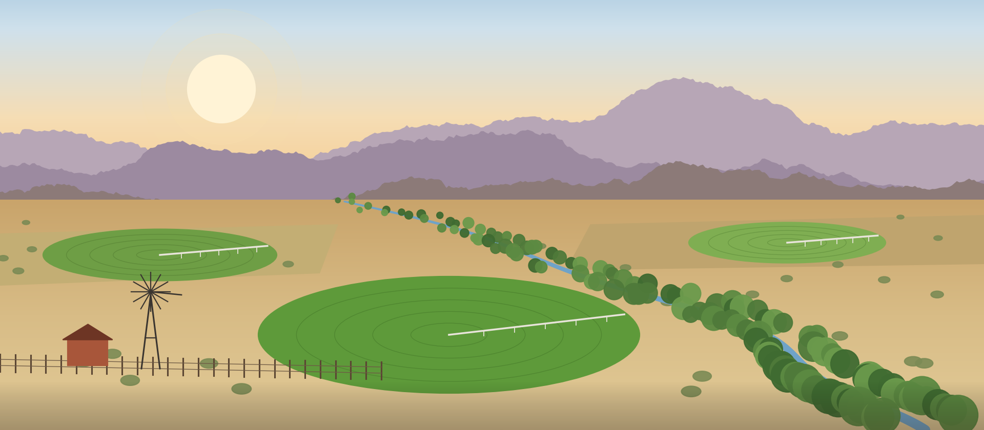
The difference is not the dirt. Plenty of valley-floor pasture sits on soils that would farm well if water reached them. What separates the two numbers is a reliable water supply and the equipment to put it on the ground.
Arizona has so little cropland farmed without irrigation that USDA withholds the non-irrigated figure. In this state, farmland without water barely exists as a category. It is simply ranch land, and it is priced that way.
Not all water is equal, either. Where it stands close to the surface and the right to use it is documented, the same acre climbs again. This post walks up that ladder one rung at a time.
The four parts of a working farm
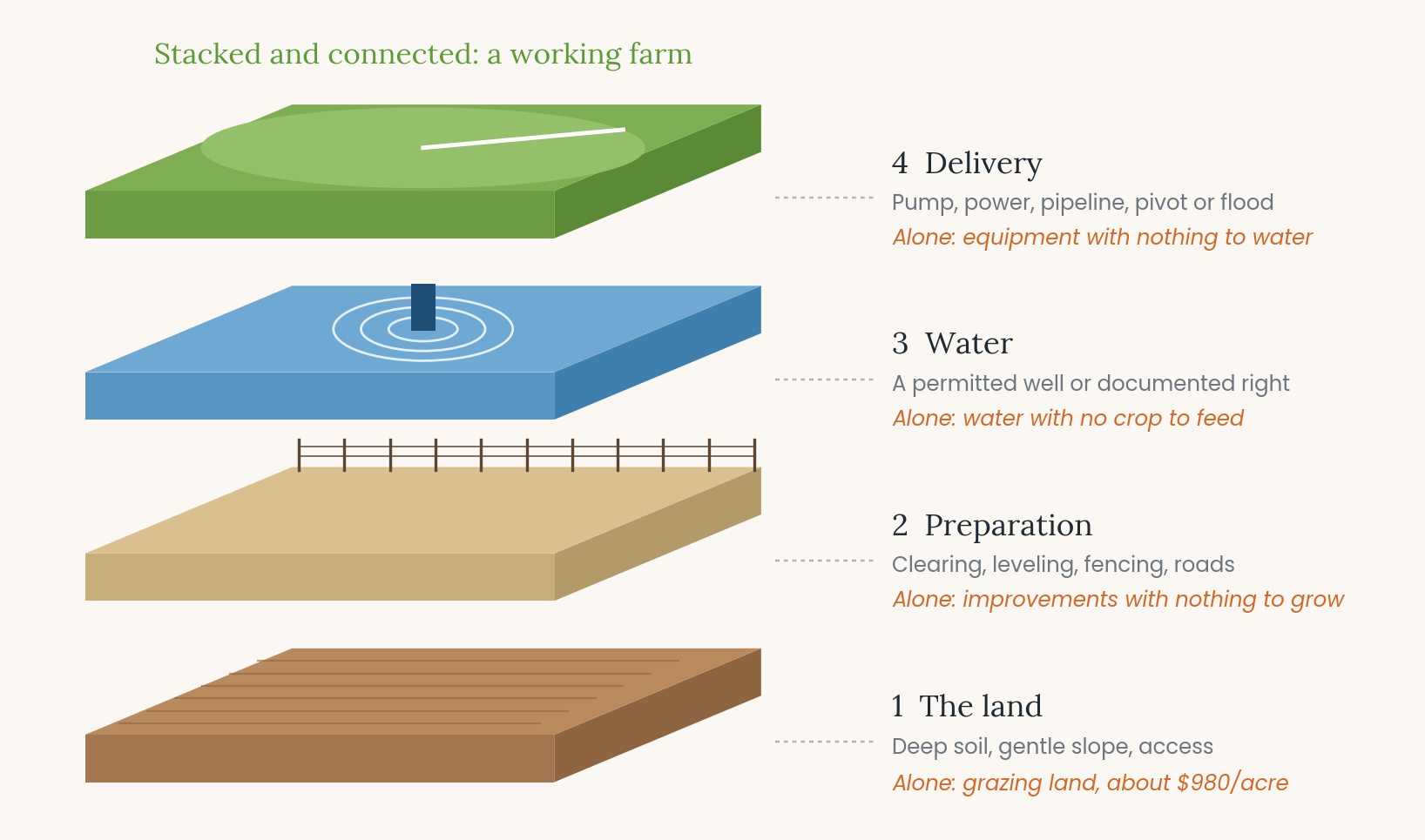
A productive farm or ranch is four things stacked on top of each other. Each one is worth little alone.
|
Part |
What it includes |
Alone, it is… |
|
1. The land |
Deep, fertile soil, gentle slope, access, elevation and climate suited to crops or livestock |
Grazing land, priced near $980/acre |
|
2. Preparation |
Clearing, leveling for even irrigation, fencing to hold stock, roads and gates |
Improvements with nothing to grow |
|
3. Water |
A drilled, cased and permitted well, or a documented surface-water or ditch right |
An asset with no crop to feed |
|
4. Delivery |
Pump, motor, power, pipeline, and a center pivot or flood system |
Equipment with no water or field |
Take away any one layer and the other three lose most of their value. That is what makes the combination symbiotic: the water makes the soil productive, and the soil gives the water something to earn.
What a new well costs, stage by stage
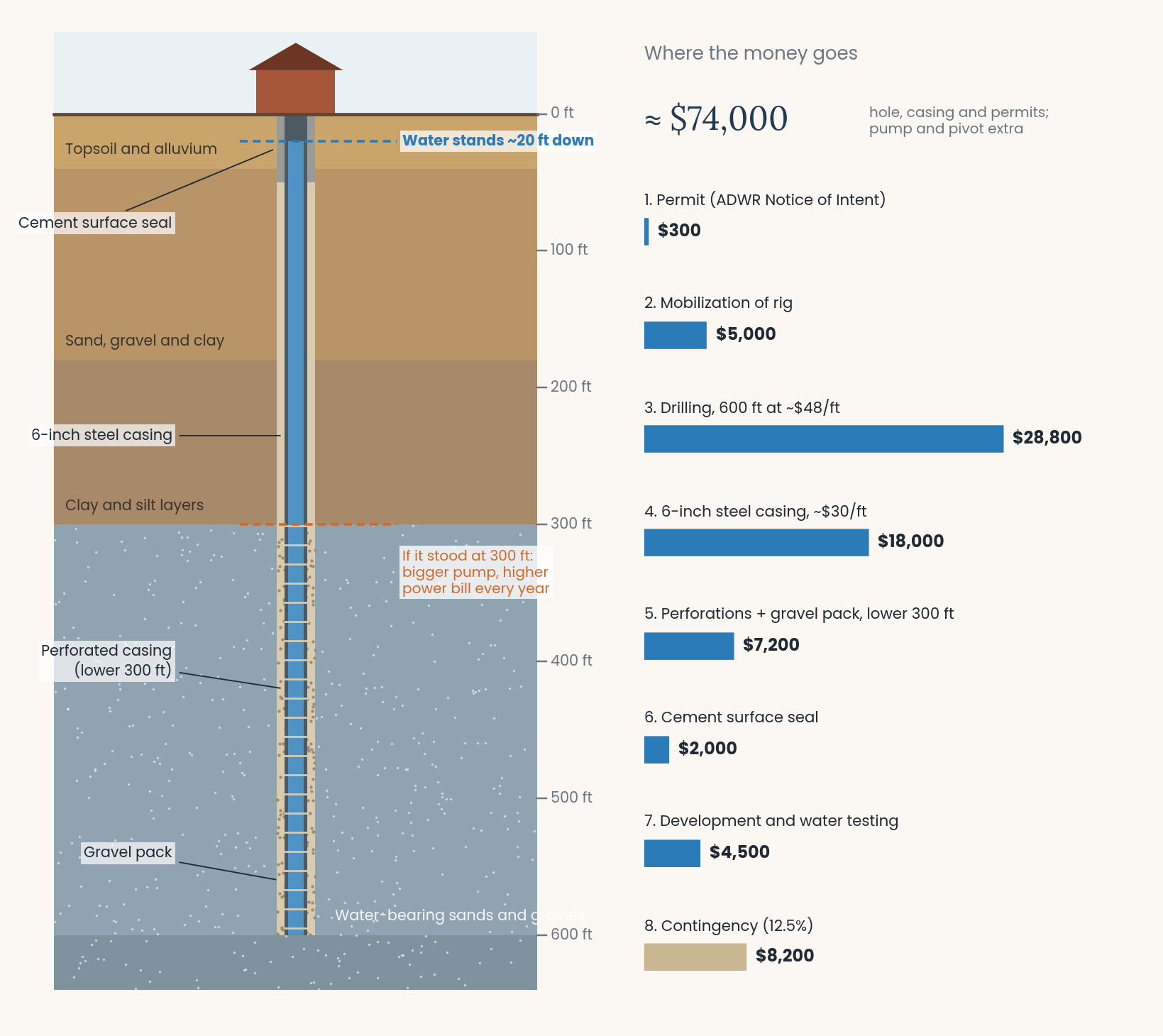
A new 6-inch steel-cased well drilled to 600 feet in southern Arizona costs about $74,000 today, with a realistic range of $53,500 to $108,000. That covers the hole, casing and permits only. The pump and irrigation equipment come on top.
Here is where the money goes, at mid-range 2026 prices:
|
Stage |
What happens |
Mid-range cost |
|
1. Permit |
File a Notice of Intent to Drill with the Arizona Department of Water Resources (ADWR) |
$300 |
|
2. Mobilization |
Move the drill rig, water truck and pipe trailer to a rural site |
$5,000 |
|
3. Drilling |
Bore a hole of about 10–12 inches, 600 ft deep, at about $48/ft |
$28,800 |
|
4. Steel casing |
Set 6-inch steel casing top to bottom, at about $30/ft |
$18,000 |
|
5. Perforations and gravel pack |
Slot the lower 300 ft of casing so water can enter, and pack gravel around it to hold back sand |
$7,200 |
|
6. Surface seal |
Cement the top of the well so surface water cannot contaminate the aquifer |
$2,000 |
|
7. Development and testing |
Pump and surge the well until it runs sand-free, then disinfect and test the water |
$4,500 |
|
8. Contingency (12.5%) |
Unknown formations, lost drilling fluid, artesian flow control |
$8,200 |
|
Total |
≈ $74,000 |
Bigger and deeper wells cost more, fast
Cost does not rise in a straight line with size. A larger casing needs a larger hole, and larger holes need a heavier rig.
|
Well |
Low |
Mid |
High |
|
4-inch casing, 600 ft |
$37,000 |
$55,500 |
$80,000 |
|
4-inch casing, 800 ft |
$47,500 |
$70,000 |
$100,000 |
|
6-inch casing, 600 ft |
$53,500 |
$74,000 |
$108,000 |
|
6-inch casing, 800 ft |
$69,000 |
$94,000 |
$136,000 |
|
8-inch casing, 600 ft |
$78,000 |
$116,000 |
$169,000 |
|
8-inch casing, 800 ft |
$99,000 |
$146,000 |
$209,000 |
|
Commercial potable: 12-inch casing in concrete to 200 ft, then 6-inch to 800 ft |
$121,000 |
$178,000 |
$269,000 |
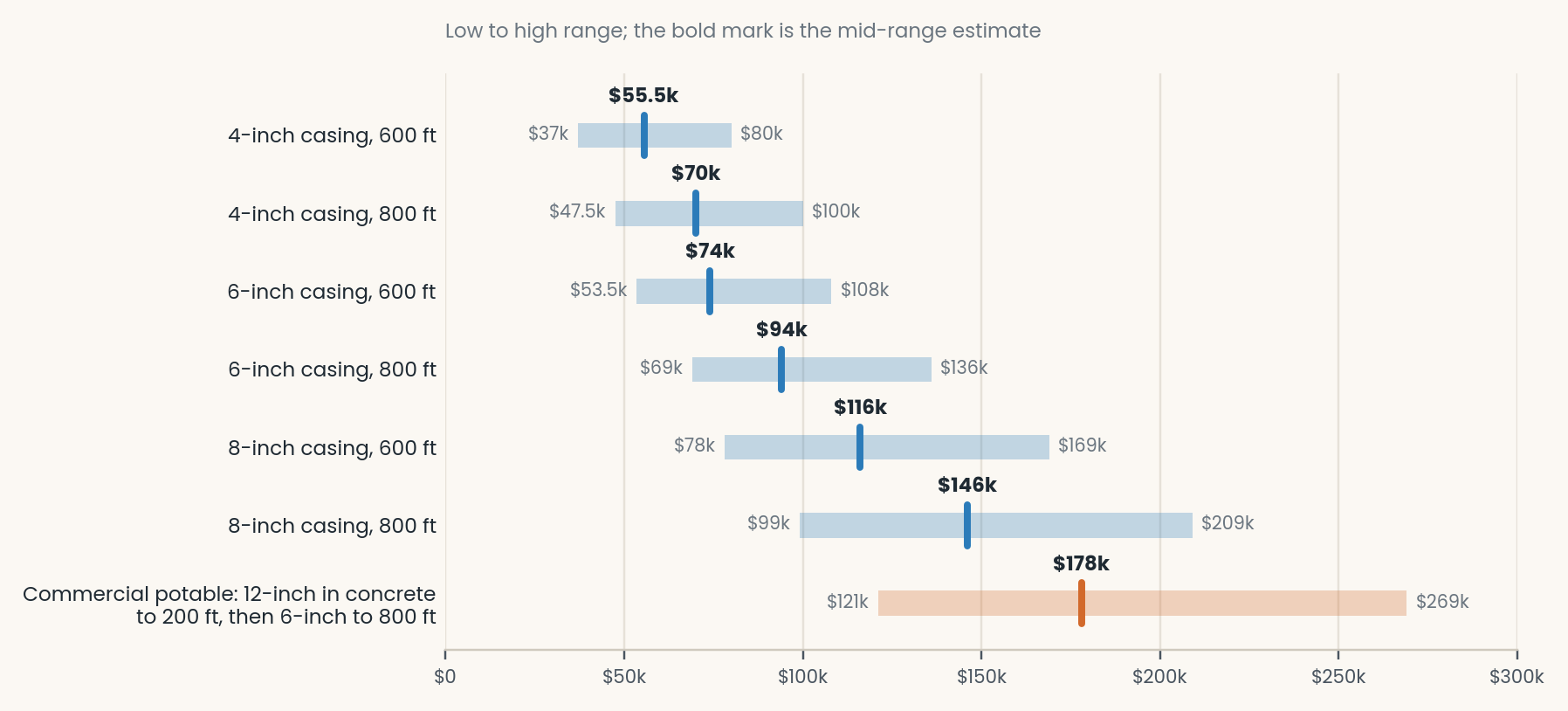
The commercial-standard well is the most expensive for three reasons. The 12-inch casing needs a 20-inch hole, which costs about three times as much per foot to drill. The heavier rig costs about $15,000 to bring in instead of $5,000. And about 320 cubic feet of cement goes around the upper 200 feet. Roughly $26,000 more covers a long pumping test, a full water-quality panel, a video survey, and state drinking-water approval.
Two more costs catch buyers by surprise. Steel tariffs have pushed 2025–26 casing prices up. And drilling into artesian (naturally pressurized) water can require heavier drilling mud and flow-control equipment, which pushes the bill toward the high end.
Why depth to water matters as much as well depth
The biggest ongoing cost of irrigation is electricity to lift water. The less distance water has to be lifted, the smaller the pump and the lower the power bill, season after season.
A well can be 600 feet deep and still have water standing 40 feet below the surface. That is a very different asset from a well where the water sits 300 feet down. Always ask for the static water level, not just the well depth.
The Willcox Basin, about 40 miles east over the Dragoon Mountains, shows what deep water does to a farm. The valley from Willcox south toward Elfrida was once a profitable alfalfa district. Water levels have dropped more than 400 feet in parts of the basin, and in December 2024 the state made it an Active Management Area to limit pumping. Many irrigation wells there now lift water from depths approaching 1,000 feet, and many of those farms are no longer in production.
Here is what that difference costs in electricity alone, for an acre of alfalfa using about six acre-feet of water a year:
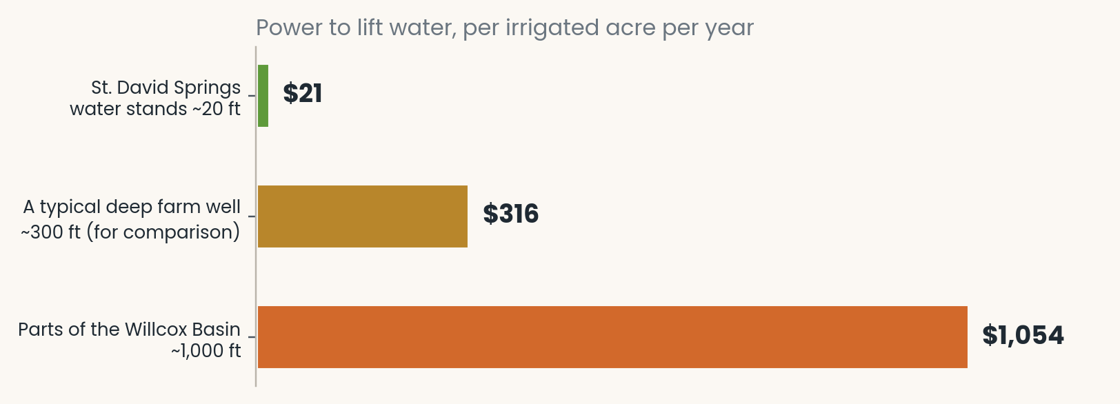
Over a 130-acre pivot, that is roughly $2,700 a year at St. David Springs against $137,000 a year from 1,000 feet. Shallow water is worth money every season. Treat the yearly saving over a 300-foot well as a permanent income, and it adds roughly $4,000 to $6,000 to the value of every irrigated acre.
That is why St. David Springs farm land is worth more than the state average. Add that saving to USDA’s $8,400, and an irrigated acre here is worth about $12,500 to $14,500. A bank appraisal backs the direction: in 2015, National Bank of Arizona appraised pivot-irrigated ground at St. David Springs at $10,500 an acre, about a third above that year’s state average of $7,970.
A well is not just a cost. It is also a gamble. Every figure above assumes the driller finds good water at the planned depth. A property with a proven, producing well has already won that bet.
Beyond the well: pump, pivot, leveling and fencing
A finished well is still just a hole with water in it. Getting that water onto a field, and keeping livestock where they belong, takes another layer of investment.
|
Item |
Typical installed cost |
Notes |
|
Irrigation pump and motor |
$8,000–$25,000+ |
Vertical turbine or large submersible, 15–100+ hp |
|
Three-phase power service |
About $8,000–$14,000 |
Depends heavily on distance to the nearest line |
|
Variable frequency drive (VFD) |
$1,500–$6,000 |
Can cut pumping power use 20–40% |
|
Center pivot |
$60,000–$120,000 |
For a system covering about 130 acres; roughly $400–$900 per acre |
|
Flood or furrow system |
$100–$400 per acre |
Ditches, gates and pipe; needs well-leveled ground |
|
Laser land leveling |
About $150–$750 per acre |
Our planning assumption: low end for touching up old fields, high end for heavy cut and fill |
|
Barbed-wire fence |
$3–$6 per linear foot (about $16,000–$32,000 per mile) |
Posts, wire, gates and labor |
For perspective, North Dakota State University priced a quarter-section pivot system in 2018 at about $90,000 for the pivot and $65,000 for the well, pump, pipeline and power. That came to about $1,200 per irrigated acre, before eight years of inflation and steel tariffs.
Adding it up: a 40-acre farm block
Building a 40-acre irrigated farm from bare pasture costs about $258,000 at mid-range prices, land included. As a working farm with water at 20 feet, a 40-acre block at St. David is worth $12,500 to $14,500 an acre, or $500,000 to $580,000. At the midpoint of $13,500, the whole is worth about $540,000, roughly twice what the parts cost.
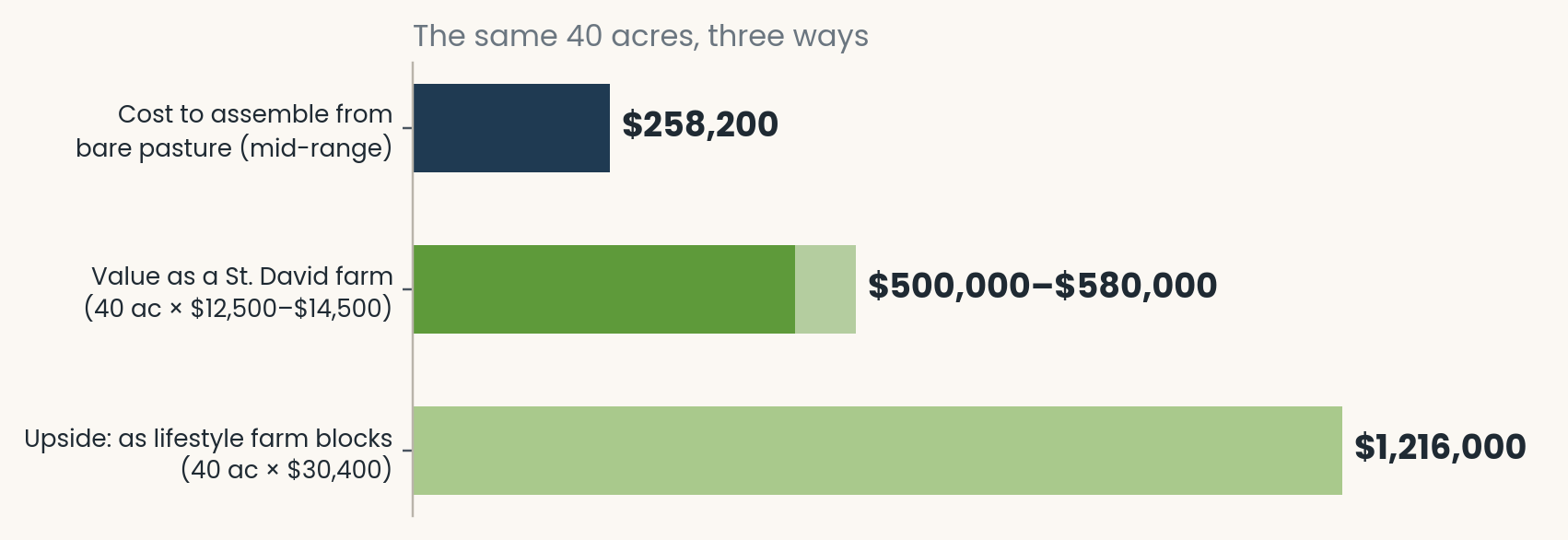
The same 40 acres, three ways. Cost at mid-range 2026 prices; farm value at $12,500 to $14,500 an acre; the lifestyle upside from the average of three closed St. David Springs land-and-well sales.
Here is the build, assuming a square 40 acres (one mile of perimeter fence), one 6-inch well and one pivot sized for the field:
|
Layer |
Low |
Mid |
High |
|
Land at pasture value (40 ac × $980) |
$39,200 |
$39,200 |
$39,200 |
|
Laser leveling (40 ac) |
$6,000 |
$16,000 |
$30,000 |
|
Perimeter fence (1 mile) |
$16,000 |
$24,000 |
$32,000 |
|
6-inch well, 600 ft |
$53,500 |
$74,000 |
$108,000 |
|
Pump, motor, power and controls |
$25,000 |
$40,000 |
$60,000 |
|
Center pivot sized for about 40 acres |
$50,000 |
$65,000 |
$80,000 |
|
Total cost to assemble |
$189,700 |
$258,200 |
$349,200 |
|
Per acre |
$4,743 |
$6,455 |
$8,730 |
|
Value as a St. David farm (40 ac × $13,500 midpoint) |
$540,000 |
$540,000 |
$540,000 |
|
Value above cost |
$350,300 |
$281,800 |
$190,800 |
|
Upside: as lifestyle farm blocks (40 ac × $30,400) |
$1,216,000 |
$1,216,000 |
$1,216,000 |
|
Value above cost |
$1,026,300 |
$957,800 |
$866,800 |
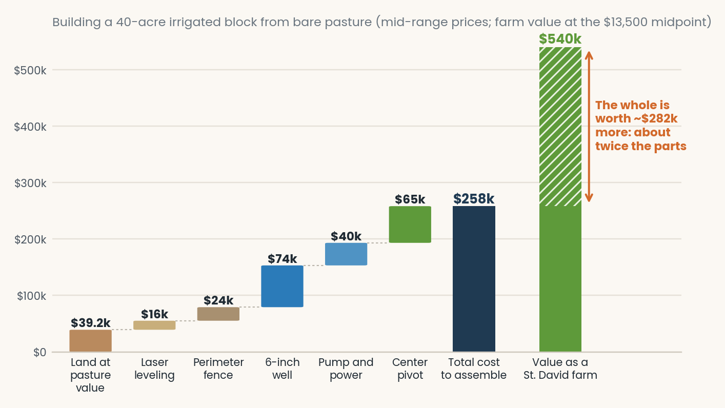
The premium for the whole comes from what the table cannot price:
- Proof. A producing well has already found water. A new one might not, or might find less than planned.
- Time. Permits, drilling, power service and pivot delivery can take many months, and every month is a season without a crop.
- Fit. The pump is sized to the well, the pivot to the field, and the field leveled to the water. Parts bought separately rarely fit this well on the first try.
- History. Documented water use, registrations and claims build up over decades. They cannot be bought new at any price.
Even in the high column, where the drilling runs deep, steel costs more and the power line is far away, the finished farm is worth about $191,000 more than it cost to build. Most of that premium is time, proof and history, which no buyer can buy new.
The same land has an upside beyond farming. Divided into lifestyle farm blocks of 8 to 40 acres, St. David Springs land has sold for an average of $30,400 an acre. At that price the same 40 acres would bring about $1.2 million.
These are planning estimates, not an appraisal. Past sales do not guarantee future prices. Real value depends on soil quality, water quantity and quality, location, zoning and the legal status of the water.
The upside: the lifestyle farm block
The $12,500-to-$14,500 figure values St. David Springs as a working farm. The same land has a second market: lifestyle farm blocks of 8 to 40 acres, with room for a home, a garden, an orchard, horses or a few head of cattle. For that buyer, value follows the home site and the water, not the crop.
What lifestyle farm blocks have sold for
Recent St. David Springs sales:
|
Sale |
What sold |
Price |
Per acre |
Closed |
|
1. 11.85 acres |
Land and well |
$350,000 |
$29,500 |
Dec 2022 |
|
2. 8.05 acres |
Land, well and mobile home |
$440,000 |
$54,650 |
Jan 2023 |
|
3. 12.97 acres |
Land and wells |
$400,000 |
$30,840 |
Jun 2023 |
|
4. 36 acres |
Land and wells |
$1,100,000 |
$30,500 |
Nov 2020 |
|
Land-and-well sales (1, 3 and 4) |
60.82 acres |
$1,850,000 |
$30,400 |
The average counts only the three land-and-well sales: total price divided by total acres. Sale 2 brought $54,650 an acre, but it included a home, so it is left out. The 36-acre sale, at $30,500 an acre, shows the price holds even at nearly the size of the 40-acre example above.
For comparison, Cochise County listings over 10 acres on Land.com carry a median asking price of about $3,000 an acre. Land with shallow, documented water, in a setting like this one, is a different market.
How land is divided in Cochise County
In Cochise County, an owner can split a parcel into five or fewer lots through a minor land division, without the full subdivision process. Three rules apply:
- Zoning minimum. Every new lot must meet the minimum size for its zoning district. The rural minimums are 2 acres (RU‑2), 4 acres (RU‑4), 10 acres (RU‑10), 18 acres (RU‑18) and 36 acres (RU‑36).
- Access. Each lot needs legal access that a two-wheel-drive passenger car can travel.
- Utilities. The division must reserve easements to bring utilities to each lot.
So zoning, not just acreage, sets how many home sites a parcel can hold. Two St. David Springs properties show how this works.
Example 1: Quail Call #1
Quail Call is four lots of 12 to 14 acres each on Highway 80, just north of Riverbend. Quail Call #1 is zoned RU‑4, which sets a 4-acre minimum and allows up to three dwellings.
That means one Quail Call #1 lot can become up to three home sites of about 4 acres or more each. Four acres is room for a house, a barn, a garden and a couple of horses. A buyer can keep all of it, or keep one site and sell or pass down the other two.

Each home site still needs water. A small farm uses far less water than a pivot field: a household, a garden and a few animals. Even so, a new 6-inch well drilled to 600 ft costs about $74,000, so ask how each site will be served before you buy.
Example 2: Escalante Crossing
Escalante Crossing is already laid out as a lifestyle farm block: five home sites of 9 to 10.9 acres, about 48.6 acres in all, along the San Pedro River. Buyers share a 50-acre private river park, with 3/8 of a mile of river frontage in a mesquite bosque. The San Pedro corridor is designated an Important Bird Area by the National Audubon Society.
The water is what sets it apart:
- An 800-foot artesian well, built to a commercial potable standard, with 12-inch casing set in concrete for the first 200 feet. Water stands just 14 feet below the surface.
- The listing puts the cost to reproduce that well at more than $200,000.
- Lot 1 also has a large artesian irrigation well, and Lot 2 has its own irrigation well.
Here the whole is again greater than the parts. One $200,000 well serving five home sites works out to about $40,000 per site. That is less than a single new 4-inch private well, and it is built to a far higher standard. Storage and distribution lines add to that figure, but the well itself, the hardest and riskiest part, is already done. Once a common road is built and electrical and water conduit is completed, each lot has value in excess of $300,000. At $30,400 an acre, a 9-to-10.9-acre Escalante lot comes to $274,000 to $331,000.
Farm value vs. lifestyle value
|
Working farm |
Lifestyle farm block |
|
|
Typical buyer |
Farmer or rancher |
A family that wants space, animals and a garden |
|
Priced by |
The acre, based on crop or grazing income |
The home site: water, access, setting and room to farm |
|
Typical size |
40 to 160+ acres |
8 to 40 acres |
|
Water need |
Hundreds of acre-feet a year |
A household plus a few irrigated acres |
|
What adds value |
Irrigated acres, pivots, well yield |
Proven water, legal access, zoning that allows division, river and mountain views |
|
Value here |
About $12,500–$14,500 an acre |
About $30,400 an acre (closed sales) |
The farm math tells you what land with water is worth to a farmer. The lifestyle block tells you what the same land and water can be worth to a family. A buyer who understands both can see the full value of a property like St. David Springs.
St. David Springs: the parts, already assembled
St. David Springs is about 850 acres of former farmsteads in the San Pedro River Valley, on State Highway 80 roughly 10 miles south of Benson. It sits at about 3,600 feet in Cochise County. Its ground has been farmed with water for more than 140 years, and every layer described above is already in place. The land is available as working farm blocks or in bulk.
850acres of former farmsteads |
21active wells and water claims |
405irrigated acres, 4 pivots |
140+years farmed with water |
Water that was organized in 1880
Between 1880 and 1883, brothers Joseph N. and Sam Curtis built the Curtis Dam, the first concrete dam on the San Pedro River, about a mile and a half north of Fairbank. It fed the St. David Ditch, which carried irrigation water north to the farms between Curtis Flats and St. David.
The great flood of 1926 washed the original dam away. An earthen dam replaced it, and St. David Ditch volunteers have maintained it ever since. In the 1960s, two large wells were drilled at Curtis Flats Farms to pump into the ditch when the river ran low. That ditch still delivers water today.
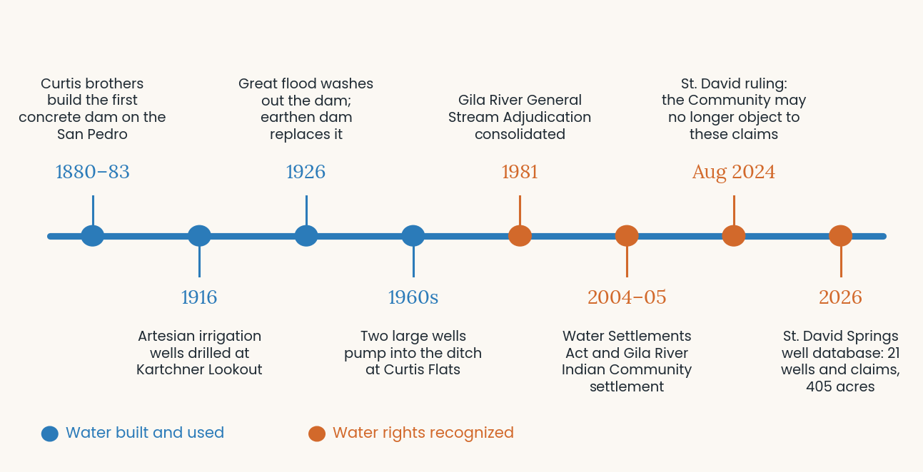
146 years of water on the ground and on paper. Blue marks water built and used; orange marks the legal recognition that followed.
What the well database shows
The St. David Springs well database documents 21 active wells and water claims across six sub-areas, with 405 irrigated acres and four center pivots.
|
Sub-area |
Water sources |
Irrigated acres |
Delivery |
|
Curtis Farms |
Irrigation, potable and stock wells; surface-water claim of 1,000 acre-feet (“Old Faithful”) |
162 |
Pivot and flood |
|
St. David Springs |
Two irrigation wells, an 800-ft headquarters well, potable and stock-water wells |
117 |
Three pivots |
|
Kartchner Lookout |
900-ft potable well; artesian irrigation wells dating to 1916 |
103 |
Artesian wells |
|
Peninsula |
37-acre parcel; St. David Ditch rights and surface-water claim |
23 |
Flood from a holding pond |
|
Escalante |
Three deep potable wells, 517 to 800 ft; ditch rights |
— |
Residential |
|
Riverbend |
800-ft commercial-standard well, well house, 1,000-gallon tank |
— |
Residential |
|
Total |
21 wells and claims |
405 |
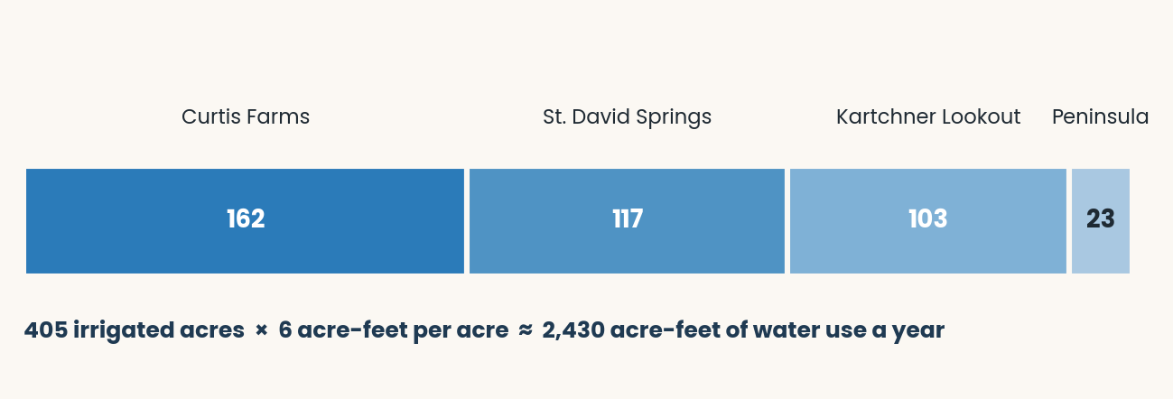
At six acre-feet per irrigated acre, those 405 acres represent about 2,430 acre-feet of water use a year. Most wells show water standing about 20 feet below the surface, though they are drilled 600 feet or deeper. Some are artesian, meaning the water is under natural pressure. The big artesian well on Curtis Farms 2 is rated at 600 gallons per minute.
The well at the farm headquarters shows how much pressure sits under this ground. It was drilled 800 feet deep to a commercial potable standard to serve a planned subdivision of one-acre mini-farm lots. With no pump at all, it flows about 40 gallons a minute at the surface.
The paper trail
The water here is documented, not just present. Each parcel carries filings with the state:
- Statements of Claimant (“39-” numbers) filed under Arizona’s Water Rights Registration Act for water used before 1995, including pre-1919 claims.
- Surface-water claims (“36-” numbers) for water from the river, springs and ditch.
- Registered wells (“55-” and “35-” numbers) in ADWR’s well registry.
A buyer who can see this record, parcel by parcel, is buying water with a history.
The strongest water right is one the courts recognize
The most valuable water is water whose right is settled. In Arizona, that happens in the Gila River General Stream Adjudication. This court case, consolidated in 1981, decides who holds the right to use water across the Gila River system, including the San Pedro River.
Two developments make the St. David area unusual:
- The Gila River Indian Community settlement. The Community holds some of the oldest and largest claims on the Gila River system. In its settlement agreement of October 21, 2005, carried out under the Arizona Water Settlements Act, the Community and the United States agreed not to challenge or object to claims for use of water from the Gila River or its tributaries (Section 28.1.3).
- The St. David ruling of August 14, 2024. In the adjudication’s St. David cases, the court’s Special Master applied that provision to claims of the St. David Irrigation District and C-Spear LLC. The Community may no longer object to the quantity, priority date or other terms of those claims. It may object only if a claimant moves its point of diversion in a way that injures the Community’s own rights.
At St. David Springs, this protection applies to the 37-acre Peninsula. Its St. David Ditch rights fall under the settlement provision that the 2024 ruling enforced.
For a buyer, that matters a great deal. A water claim on file in the adjudication, backed by a century of documented use and shielded from objection by the holder of some of the river’s most senior claims, is about as secure as water gets in Arizona short of a final decree.
That final decree has not yet been issued for the San Pedro. The Arizona Department of Water Resources is still mapping which wells tap the river’s subflow, and the St. David Springs database maps that zone for each parcel. Other parties, including the United States, can still raise objections. Ask whether a property’s claims fall within the protected cases, and have a water-rights attorney confirm it.
What it would cost to rebuild
Three of the wells (Escalante E-1, Riverbend R-1 and Headquarters) were built to a commercial potable standard: 800 feet deep, with 12-inch casing set in concrete for the first 200 feet. Replacing one with 6-inch casing below the concrete section would cost about $178,000. The Escalante well sheet shows 8-inch casing below that section, which raises its replacement cost to about $212,000. Together, the three would cost roughly $570,000 to rebuild.
The 11 wells with enough data to price would cost about $1.1 million to drill new today (range $769,000 to $1.62 million). That figure covers only the wells. It excludes pumps, pivots, ditches, fencing, leveling and more than a century of documented water use.
A buyer’s checklist for land with water
Before you pay for water, verify it. Ask the seller for these, and have your own experts review them.
- Well registrations. The ADWR registration number (“55-”) for every well, plus the driller’s log showing depth, casing size and perforated interval.
- Water claims and rights. Any Statements of Claimant, surface-water claims and ditch rights; where those claims stand in the Gila River adjudication, including whether they are protected by the Gila River Indian Community settlement; and whether the land lies in a groundwater management area or the San Pedro subflow zone.
- Yield. A recent pump test showing gallons per minute the well can sustain, not just what it produced when drilled.
- Static water level. How far below the surface the water stands. Shallow water means lower pumping costs every year.
- Water quality. A certified lab test, sampled with a documented chain of custody from the wellhead to the lab.
- Irrigation history. Which acres were actually irrigated, for how long, and by what method.
- Equipment condition. The age and condition of pumps, motors, pivots and power service, and whether three-phase power reaches the well.
- The ground itself. Soil type (the USDA Web Soil Survey is free), slope, leveling and the condition of fences and gates.
- Replacement cost. What it would cost to rebuild the wells and irrigation if you had to start over. That is the floor under the value of what is already there.
Arizona’s rules for rural groundwater are changing. Check the current status of any property with ADWR and a water-rights attorney before you buy.
The bottom line
Land without water is ranch land. Water without good land is a well with nowhere to go. Farm and ranch value in southern Arizona comes from having both, prepared and connected, with the paperwork to prove it.
Building that combination from scratch costs a quarter-million dollars or more for a single 40-acre field, takes months, and carries the risk of a disappointing well. At St. David Springs, the soil, the water, the delivery systems and 140 years of documented use are already in place. And because much of the land can be divided into lifestyle farm blocks like Quail Call and Escalante Crossing, that water can serve families as well as farmers. That is what “the whole is greater than the sum of its parts” looks like on the ground.
Forty miles east, in the Willcox Basin, farms that once grew alfalfa sit idle because their water fell too deep to lift. Here the water stands about 20 feet down, costs about $21 an acre a year to lift, and comes with paperwork going back more than a century. Whether it is bought in bulk as a working farm or divided into lifestyle blocks, that is water worth paying for.

Sources and notes
Well costs are planning estimates in 2026 dollars, built from published Arizona pricing and a 2024 public well bid. They are not driller quotes or an appraisal. Leveling and the 40-acre pivot and pump figures are our planning assumptions; get local bids before relying on them. Sale prices are closed St. David Springs transactions; the 2015 appraisal is a private bank appraisal. Pumping costs assume a 70%-efficient pump and $0.12 per kWh. Illustrations and charts are drawn for this post from the figures cited here.
- USDA NASS, Land Values 2026 Summary — Arizona pasture and irrigated cropland values
- USDA NASS, Land Values 2019 Summary — Arizona irrigated cropland, 2015 ($7,970/acre)
- National Bank of Arizona appraisal (2015) — pivot-irrigated ground at St. David Springs, $10,500/acre
- St. David Springs closed sales, 2020–2023 — four lifestyle farm block sales
- ADWR, Willcox Active Management Area — designated December 2024
- AZPM, Willcox groundwater basin designated as Arizona’s 7th Active Management Area — water levels down more than 400 feet in places
- WellDrillingCost.com, Arizona Well Drilling Cost 2026
- WellDrillingCosts.com, Arizona well drilling cost by county
- WellDrillingCosts.com, Irrigation well drilling cost — pumps, three-phase power, VFDs
- Cedar City, Utah, Mud Springs Production Well bid tabulation (April 2024) — large-diameter unit prices
- FarmCalcs, Farm irrigation systems guide (April 2026) — pivot and flood costs
- NDSU Extension, Irrigation FAQ — 2018 quarter-section pivot cost
- HomeGuide, Barbed wire fence cost (2026)
- ADWR, Well drilling in Arizona
- St. David Springs, Curtis Farms 2 listing — 600 gpm artesian well
- St. David Springs Well Database (June 27, 2026) — well records, claims, irrigated acres and Curtis Dam history
- Cochise County, Minor Land Division — five-or-fewer lot rule, access and zoning requirements
- Cochise County, Summary of Zoning Districts — rural minimum lot sizes
- St. David Springs, Quail Call listing (Feb 2026)
- St. David Springs, Escalante Crossing listing (Feb 2026)
- St. David Springs, Escalante Crossing well sheet (Mar 2025) — 800-ft artesian well, 14-ft static level
- Land.com, Cochise County land market — asking prices per acre
- Maricopa County Superior Court, ruling in St. David cases W1-11-2081 et al. (Aug 14, 2024) — Gila River Indian Community precluded from objecting to claims
- Arizona General Stream Adjudication Bulletin, June–Sept 2024 — San Pedro subflow and status
- ADWR, Gila River and Little Colorado River General Stream Adjudications
- Arizona Water Settlements Act, Public Law 108-451 (2004)